|
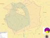

IMAGE 2-1
Enrollment population within the 1855 Treaty Boundary, the
1863 Treaty Reservation, and ICC Territory
|
|
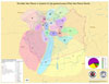
IMAGE 2-2
Enrollment population in location to the estimated location of Nez Perce Band homelands
|
|
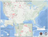
IMAGE 2-3
Location of enrolled Nez Perce that are scattered throughout the United States
|
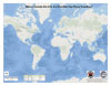
IMAGE 2-4
Location of enrolled Nez Perce that live outside the United States
|
|
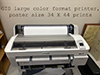
IMAGE 2-5
Land Services GIS uses large format printer to produce maps or large formated posters for viewing
|
|
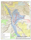
IMAGE 2-6
FIRE Evacuation zones within the Greer area 8-20-2013
|
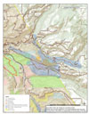
IMAGE 2-7
FIRE Evacuation zones within the Orofino area 8-20-2013
|
|
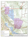
IMAGE 2-8
FIRE Evacuation zones within the Weippe area 8-20-2013
|
|
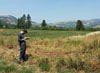
IMAGE 2-9
Mike out in the field using his GPS skills.
|

IMAGE 2-10
Employee of the month (March 2014).
|
|
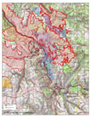
IMAGE 2-11
FIRE map - Clearwater Complex 8-19-2015
|
|
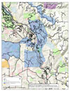
IMAGE 2-12
FIRE Evacuation zones within the Kamiah area 8-20-2013
|
)
)
)
)
)
)
)
)
)
)
)
)