About Us The Nez Perce Land Services and all the programs that are under it.
The geographic information system (GIS) program resides within the Nez Perce Tribe Department of Natural Resources and within
the Department of Natural Resources is the Land Services Program. The Land Services Program has
four
program components which are: Agriculture Management Program, GIS Program,
Biocontrol Center Program
and Nez Perce Horse
Registry.
Goals and Objectives In depth to how we plan to reach our goals and objectives.
The
mission of the GIS/Remote Sensing (RS) program is to provide a geographic information
foundation to support effective natural resources management. The
GIS/RS program will provide the technological vision and leadership to
deploy appropriate spatial technologies that will contribute towards an
improved ecosystem.
Program Functions Seven program functions have been identified by the GIS/RS staff, and are listed below.
1. System Administration The crux of a GIS/RS program is the proper configuration and maintenance of a multi-user computer and printing system. This process requires continuous management of the following tasks:
Software and firmware updates
system troubleshooting and problem solving
user accounts and data security
file management and system archives
system backup and restore
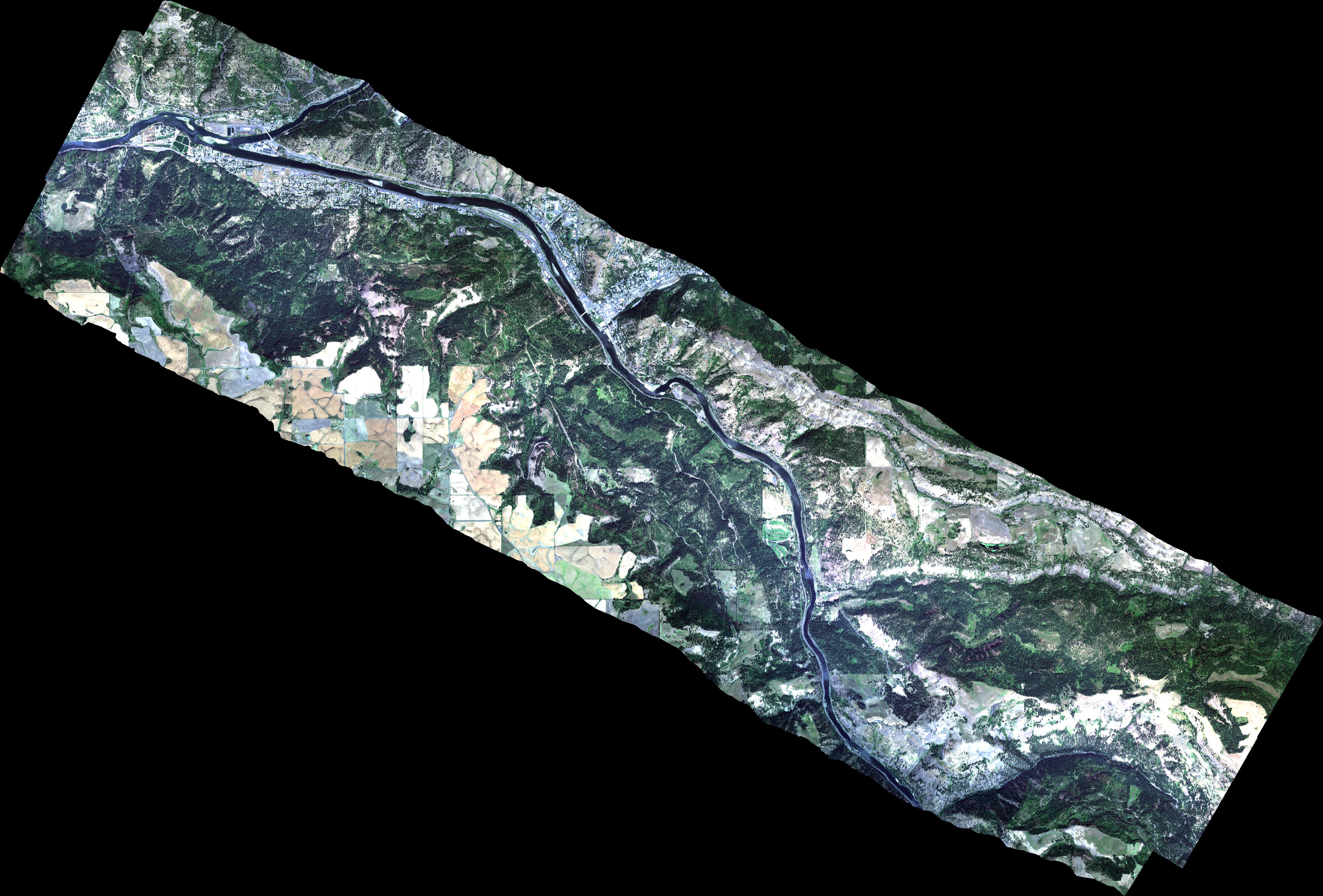
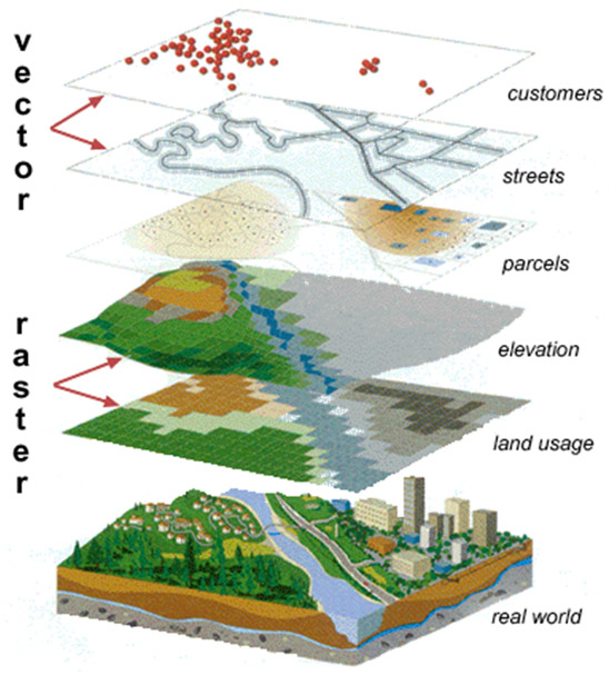
2. Data Documentation and Organization Adequate development and maintenance of the GIS/RS information base is the foundation for realizing the system's function and capacity.
Useful databases are based on careful and consistent organization of information from various sources and formats. Developing metadata - information about data - is vital to the process of making accurate, useful data available for tribal projects.
The following activities are part of the data documentation and organization process:
GIS database design, development, and maintenance
FGDC compliant metadata design, development, and maintenance
Data acquisition, data synthesis and data assimilation
3. Network Connectivity Provide high speed network connectivity to GIS/RS information services. With the support and expertise of the Nez Perce Tribe's Information Systems Division, updated network connections to the GIS/RS database servers will be established, monitored, and maintained for optimal data access and transfer speeds. The following activities are part of the network development function:
Technical coordination and consultation from the Nez Perce Tribe's Information Systems division
Update network connectivity structure and services that are conducive to improved data access and transfer between data servicers, data collection devices, and staff workstations
4. GIS/RS/GPS Consulting Services
Initiate GIS/RS consulting services that provide clear insight to proper geospatial and spatiotemporal data collection, documentation, storage, retrieval, maintenance, and investigation procedures. This service will require the following activities:
Devise technical workgroup meetings between GIS/RS staff and program representatives as a GIS/RS information sharing and GIS/RS data collection venture
Technical support to tribal programs requiring the design, development, and implementation of GIS/RS/GPS data
Continuous review and modification of the GIS/RS Personnel Task descriptions to accommodate tribal programs with timely GIS/RS support
GIS/RS/GPS software support to tribal staff trained in using ESRI, Trimble, and/or Leica Geosystems products
Land Services Director approved project level support (support requiring extensive GIS/RS staff resources) to tribal programs
5. Data Maintenance
Dynamic data requires continuous maintenance; thereby, providing tribal land managers with current or near real-time information. To achieve a near real-time geospatial database, the following activities must be
incorporated:
Create a notification process between tribal staff and GIS/RS database administrators
to relay revised or new geospatial information
Create geospatial data update procedure for GIS/RS database administrator
Create FGDC compliant metadata update procedures to reflect any changes or additions to current data holdings
6. Data Presentation
Data, and operations performed upon that data, can be presented as an image file, paper document,
a poster, MS Power Point, or within an interactive internet mapping system website. The GIS/RS program provides printing, data transfer, and internet map development
services to tribal programs. The GIS/RS program provides the following information exchange services:
Cartographic map display and printing
Large data transfer through FTP services
Interactive internet map displays
Map development consultation to tribal ESRI and Leica Geosystems software users
7. Education
The GIS/RS program will provide information and education services to tribal staff concerning GIS/RS technologies, geospatial analysis, and geospatial data storage and retrieval.
Nez Perce Tribal Programs that use GIS Other Tribal programs that we work close with and also have GIS positions.
The Nez Perce Tribe GIS program would like to
acknowledge the other Nez Perce Tribal programs that hold GIS positions:
Nez Perce Tribe Fisheries, Nez Perce Tribe Water Resources, Nez Perce Tribe
Wildlife, Nez Perce Tribe Forestry and Culture Resources.


 The Nez Perce Tribe GIS program would like to
acknowledge the other Nez Perce Tribal programs that hold GIS positions:
Nez Perce Tribe Fisheries, Nez Perce Tribe Water Resources, Nez Perce Tribe
Wildlife, Nez Perce Tribe Forestry and Culture Resources.
The Nez Perce Tribe GIS program would like to
acknowledge the other Nez Perce Tribal programs that hold GIS positions:
Nez Perce Tribe Fisheries, Nez Perce Tribe Water Resources, Nez Perce Tribe
Wildlife, Nez Perce Tribe Forestry and Culture Resources.